Everyone In Washington Needs To Take These 10 Short Hikes With Seriously Big Views
One of these trails climbs the inside of a giant rock core using switchbacks and bridges, and the whole trip is under two miles.
You’d expect a walk that short to end at a modest viewpoint. Instead, it ends high above the Columbia River with a view that keeps going.
The surprises stack up from there.
One short climb in Washington ends at a 67-foot fire lookout tower built in 1965, with Bridal Veil Falls and Mount Index right in your face.
Another path to a famous waterfall is paved and wheelchair accessible, with poetry on signs along the way.
So how much scenery can you really squeeze into an afternoon walk? Quite a lot, it turns out.
Which one are you lacing up for first?
1. Beacon Rock Trailhead
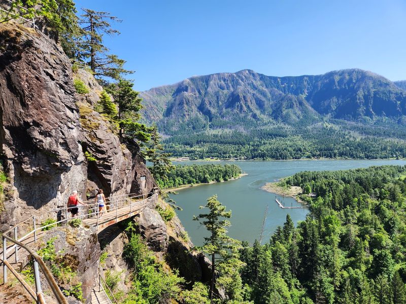
Most rocks just sit there, but this one comes with its own staircase of switchbacks and bridges. The trail zigzags up the face of an enormous basalt landmark in the Columbia River Gorge.
You cover about 1.8 miles out and back, gaining roughly 570 feet. That sounds manageable until you realize how many turns are packed into the climb.
The trail has dozens of switchbacks, with metal railings and elevated walkways carrying hikers around the steepest sections.
Here’s the fun part. River views begin before the summit, so the scenery keeps changing as you climb. Boats move far below, forest covers the opposite hillsides, and the path folds beneath you in a remarkable pattern.
The summit offers a sweeping panorama rather than a scramble across exposed rock. Stay behind the railings and enjoy the remarkable engineering that makes this climb possible.
Leashed dogs can accompany hikers, and restrooms are available near the parking area.
There’s one especially important 2026 detail: the Beacon Rock summit trail closes on Tuesdays, Wednesdays, and Thursdays through May 2027 for decking replacement. Other park trails remain available during those closures.
A Discover Pass is required for vehicle parking. The trail’s narrow turns are best enjoyed at an unhurried pace, especially when other hikers are coming downhill.
For this Washington gorge adventure, use Beacon Rock State Park, 34841 State Route 14, Skamania, WA 98648.
2. Heybrook Lookout Trailhead
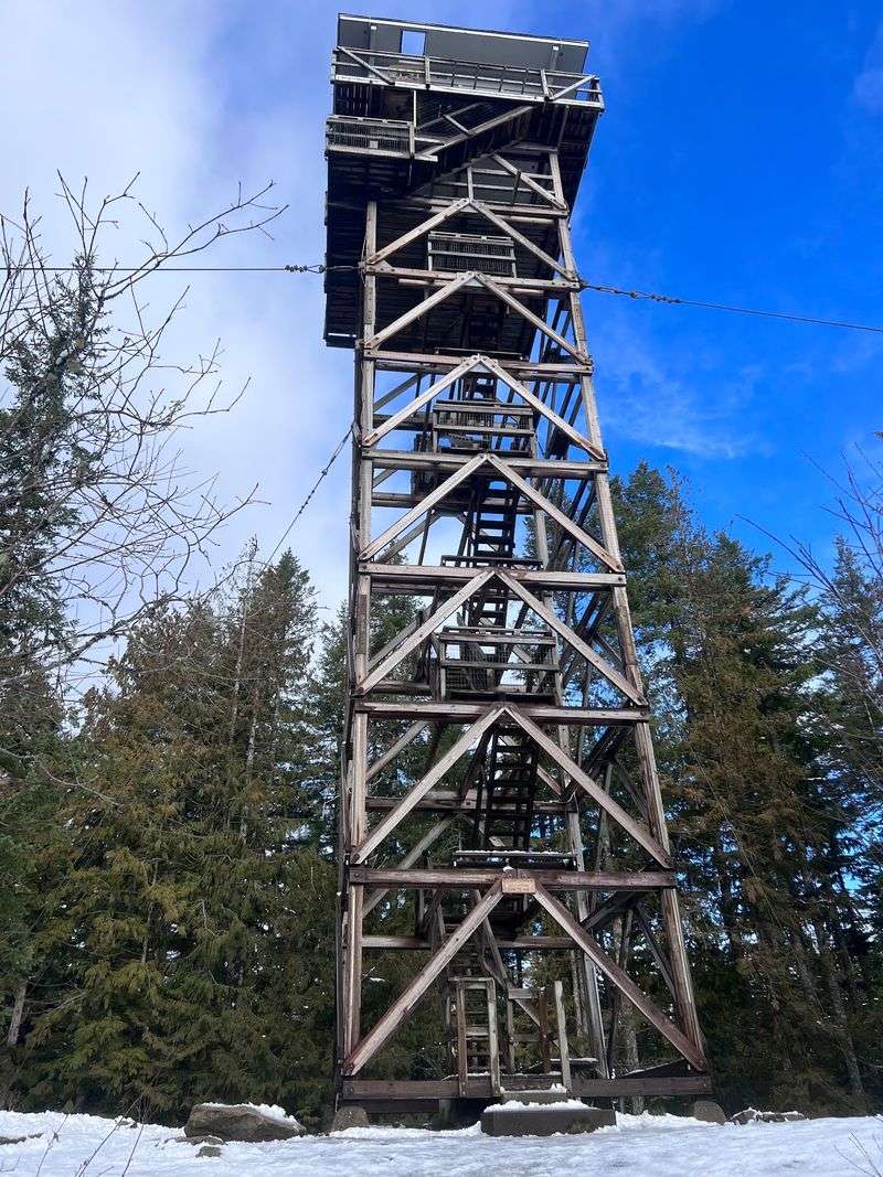
A 67-foot fire tower waits at the top of this climb, and yes, you can climb its stairs to an observation platform.
That’s a pretty great bonus for a hike of about two miles round trip.
Fair warning: the trail is short but steep. It gains roughly 980 feet, climbing through ferns, mossy trees, and thick forest before reaching the ridge. The steady ascent makes the final approach feel thoroughly earned.
Lookouts have stood here since 1925. The present tower was constructed in 1964, and its stairs lead to a viewing level beneath a small cabin.
The cabin itself is reserved for overnight guests, but the lower observation platform offers a remarkable view for day hikers.
Mount Index dominates the skyline, with Bridal Veil Falls visible on its slopes in clear conditions. Mount Baring and Mount Persis add another layer of jagged peaks beyond the Skykomish Valley.
A picnic table near the tower provides a place to rest before heading downhill. Leashed dogs are welcome, and no parking pass is required. There are no restrooms at the roadside trailhead, however, so plan accordingly.
Parking is limited beside Highway 2, and the trail can be muddy after rain. On a clear morning, the surrounding peaks look especially crisp above the evergreens.
You’ll find the trailhead just beyond milepost 37 on US Highway 2 near Gold Bar, WA 98251.
3. Heybrook Ridge Trailhead
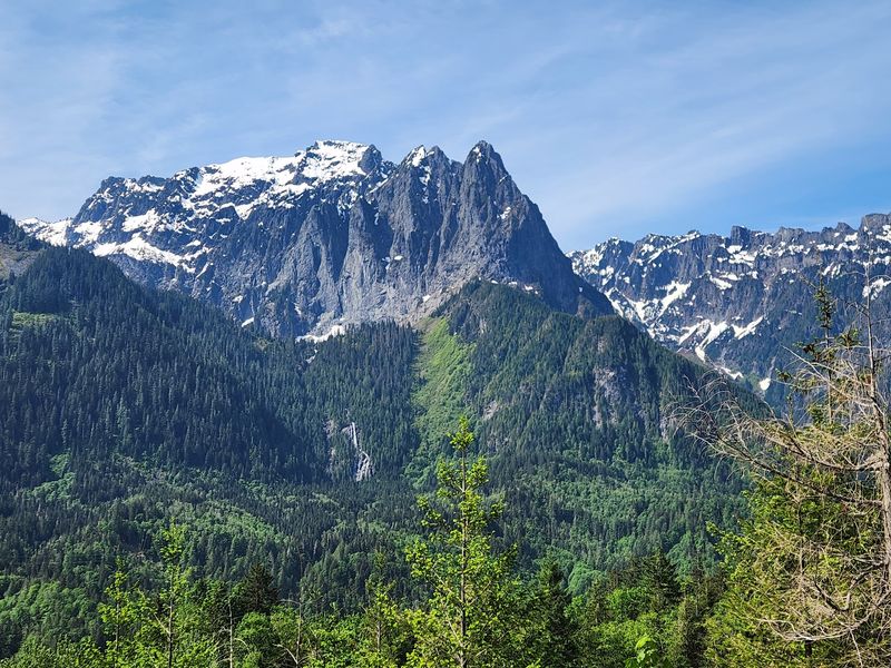
Call it the lookout’s quieter neighbor. Heybrook Ridge shares the same mountain backdrop but follows a different route from the Index side of the valley.
The Leovy Trail climbs through second-growth forest along carefully graded switchbacks. Its approximately 3.3-mile round trip gains about 775 feet, making it a moderate outing rather than a quick half-mile stroll.
Moss, ferns, and tall trees make the uphill portion feel like a walk through a green tunnel.
At the viewpoint, Mount Index rises dramatically above the Skykomish Valley. Bridal Veil Falls can be visible on the mountainside, particularly when the sky is clear. The panorama feels especially rewarding after the quiet woodland approach.
There is now another option for a shorter visit. In October 2026, the park reopened with the new Erinswood Loop, a half-mile accessible path with gentle grades, interpretive signs, and benches.
It’s a thoughtful choice for families wanting forest scenery without the full ridge ascent.
Heybrook Ridge County Park grew from a local conservation effort, and its trails are maintained with community support.
Leashed dogs are permitted, but the parking area is small and has no toilet facilities. The two routes offer very different experiences within the same protected landscape.
Choose the ridge for mountain views or the new loop for a gentle stroll. Start at Heybrook Ridge County Park, 50606 Index-Galena Road, Index, WA 98256.
4. High Rock Lookout
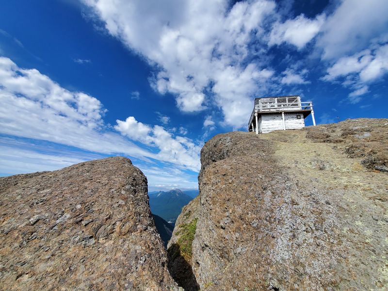
A tiny fire lookout cabin clings to the top of this rock, and the cliffs below it drop away in spectacular fashion. Heights fans, this one’s for you.
The trail follows Sawtooth Ridge for about 1.6 miles each way, climbing roughly 1,365 feet. It’s a genuine uphill hike despite the modest distance, with roots, steep sections, and increasingly open views as you approach the summit.
On clear days, Mount Rainier fills the skyline. Other Cascade peaks may appear beyond the surrounding valleys, and the exposed rock makes the final stretch feel particularly dramatic.
This isn’t a casual paved viewpoint, so sturdy footwear and careful footing matter.
The historic lookout has been undergoing restoration. As of October 2026, the trail and trailhead are open, but the lookout itself and the surrounding 150-foot area remain closed through October 31.
Respect the barrier and enjoy views from permitted points along the trail rather than approaching the structure.
Access roads are rough, and the upper route can become snowy outside the warmer months. The small trailhead has no restroom, so bring water and everything needed for the outing, including a snack.
High Rock is one of Washington’s more adventurous short climbs, and the restoration is helping preserve its remarkable summit landmark. For access, follow Forest Roads 84 and 8440 to Towhead Gap near Ashford, WA 98304.
5. Picture Lake Viewpoint
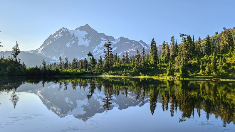
Some lakes earn their names honestly, and this one practically poses for the camera. Calm water mirrors rugged Mount Shuksan so perfectly that the reflection can look like a second mountain.
A short, accessible path circles Picture Lake in the Heather Meadows area.
The loop is roughly half a mile, with pavement and boardwalk sections designed for an easy stroll. It’s an excellent choice for families, wheelchair users, and anyone who wants alpine scenery without a strenuous climb.
The real star isn’t Mount Baker reflected in the water. It’s Mount Shuksan, whose sharp summit rises above the lake’s southern shoreline. Nearby Mount Baker adds to the surrounding alpine landscape, but Shuksan creates the classic mirrored composition.
In summer, wildflowers brighten the banks. Autumn brings golden shrubs and changing leaves, while snow can linger around the road and trail well into the warmer season.
A calm morning offers the clearest reflections before breezes disturb the surface.
This delicate mountain lake is for viewing rather than swimming. Boating and entering the water aren’t allowed, and pets must remain out of the lake. Leashed dogs may use the surrounding path.
The route lies along the Mount Baker Highway below Artist Point, with roadside parking near the lake. Find the loop at Picture Lake, Heather Meadows, State Route 542, Deming, WA 98244.
6. Artist’s Ridge
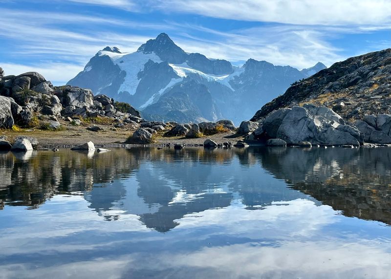
Talk about efficient. You park near the end of a scenic highway, walk a short ridge, and suddenly two giant peaks are staring back at you.
Artist Ridge begins near Artist Point, high above the Mount Baker Highway.
The route to Huntoon Point runs approximately 1.2 miles round trip, with only about 200 feet of elevation gain. It’s a modest walk, but the setting feels like a much larger alpine expedition.
Mount Baker dominates one direction, while Mount Shuksan rises in the other.
Table Mountain, distant ridges, small tarns, and patches of summer wildflowers add detail between the peaks. The open landscape makes nearly every turn a natural stopping place.
Snow is the main complication. The final highway section usually opens around summer and closes again after substantial autumn snowfall.
The 2026 road reopened in June, though seasonal access can change quickly when conditions shift. Check the road status before traveling, especially late in the year.
A Northwest Forest Pass or accepted interagency pass is required at Artist Point. Leashed dogs may join the walk. Even on sunny days, bring an extra layer because the wind can feel surprisingly brisk at this elevation.
The payoff arrives almost immediately, which is exactly why this ridge is so appealing. Reach the trail from Artist Point parking at the end of State Route 542, Deming, WA 98244.
7. Mount Fremont Lookout Trail
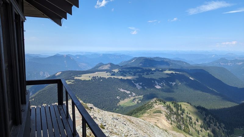
Mount Rainier is the neighbor that never lets you forget it’s there. On this trail, the mountain dominates the scenery long before you reach the historic lookout.
The route covers 5.6 miles round trip from Sunrise, with roughly 900 feet of elevation gain according to the national park.
It’s the longest outing on this list, demanding several hours rather than a quick walk after lunch.
From the parking area, the path climbs Sourdough Ridge and reaches Frozen Lake. Another stretch follows a rocky mountainside to the lookout, built in 1934 at an elevation of about 7,181 feet.
On a clear day, the Cascade Range and distant Olympic Mountains fill the horizon.
There’s a crucial access restriction for 2026. The Mount Fremont Trail is closed until further notice under the Grand Park 2 area restrictions, and Sunrise Road is closed to vehicles and pedestrians for the season.
When access resumes, expect exposed terrain, changeable mountain weather, and a high-elevation setting with little shade.
Dogs aren’t allowed on national park hiking trails. The route also crosses fragile alpine terrain, where staying on established paths protects plants in summer.
For future planning in Washington, the trail begins at the Sourdough Ridge trailhead beside Sunrise parking, Mount Rainier National Park, near Enumclaw, WA 98022.
8. Rattlesnake Ledge
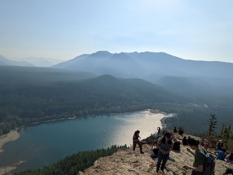
Don’t worry, the name sounds scarier than the hike. What you actually get is a rocky ledge hanging high above a gorgeous lake.
The trail climbs about two miles each way through forest, with roughly 1,160 feet of elevation gain. It’s a steady workout, winding through tall evergreens before emerging onto a broad overlook.
The total four-mile round trip makes this more demanding than its convenient location might suggest.
From the ledge, Rattlesnake Lake spreads out below. Mount Si, Chester Morse Lake, and the surrounding Cascades complete the scene. The exposed viewpoint has steep edges, so stay well back while admiring the scenery.
The hike begins near the lake’s day-use recreation area, about a short drive from Interstate 90. It’s especially popular on weekends, and arriving early can make parking and the ascent more comfortable.
Leashed dogs are welcome. Nearby lake activities include paddling, fishing under state rules, and swimming at your own risk, since there are no lifeguards.
The recreation area has restrooms and picnic areas but no drinking water near the trailhead. For an easier second walk, the mostly flat lakeside route toward the Cedar River Watershed Education Center offers a gentle finish.
The site is open from dawn to dusk, with free parking at the lake area. Begin the climb beside Rattlesnake Lake on Cedar Falls Road Southeast, North Bend, WA 98045.
9. Sol Duc Falls
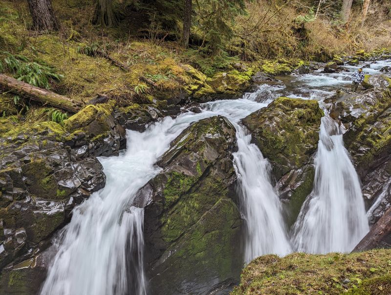
Few waterfalls make an entrance like this one. Water tumbles into a narrow canyon while you stand on a wooden bridge right above the action.
Getting there is the easy part. The trail measures about 1.6 miles round trip with roughly 200 feet of elevation gain.
From the parking area, it winds through old-growth forest, passing enormous trunks, mossy branches, and ferns before reaching the waterfall.
Sol Duc Falls splits into several channels as the river drops into a rocky gorge. The bridge provides a remarkable view into the churning water, while surrounding trees frame the scene from nearly every angle.
This short route is popular with families, although roots, steps, and damp sections mean the path isn’t an accessible paved walkway. Take your time when the ground is slippery after rain.
The Sol Duc area of Olympic National Park was open in late October 2026, but access is seasonal and the road may close during colder weather. Confirm road conditions before setting out. Pets aren’t allowed on this national park trail.
Restrooms are available near the trailhead, and national park entry requirements apply. There’s enough scenery along the approach to make the forest walk a highlight in its own right.
Reach the trailhead by following Sol Duc Hot Springs Road through Olympic National Park, west of Port Angeles, WA 98363.
10. Madison Falls Trailhead
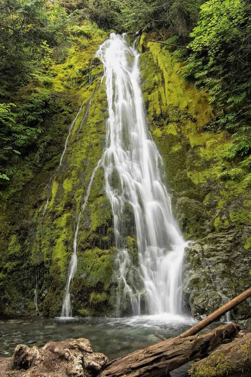
Poetry on trail signs, giant mossy trees, and a waterfall at the end. Not bad for a walk you could finish before your coffee cools.
Madison Falls sits along a paved path in the Elwha Valley of Olympic National Park.
The walk is only about a tenth of a mile each way, with a gentle slope that makes it one of the park’s most accessible waterfall outings.
The falls tumble roughly 60 feet down a wooded rock face. Moss-covered trees and lush undergrowth frame the water, while the nearby Elwha River adds another beautiful stop beside the parking area.
Those poetry signs are a special seasonal touch. During the North Olympic Library System’s 2026 Poetry Walks program, from April through May, poems appeared beside the Madison Falls Trail and several other local paths.
They’re part of a temporary event rather than a year-round exhibit.
This is one of the few Olympic National Park trails where leashed dogs are welcome. A vault toilet is available near the gravel parking area, and the short approach suits strollers and many wheelchair users, depending on conditions.
The route provides an especially gentle finish to a day exploring Washington waterfalls. The short approach lets you hear the falling water before it appears.
Start from Madison Falls Trailhead on Olympic Hot Springs Road in the Elwha Valley, Port Angeles, WA 98363.