Paddle 2 Miles Through An Idaho Canyon To Reach Two 100-Foot Rock Pillars In The River
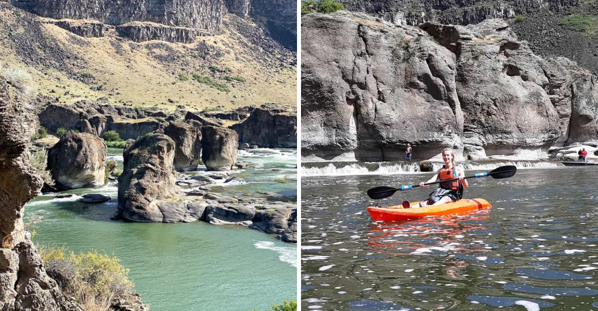
I knew the paddle was going to be the easy part.
Then the canyon started closing in.
The farther I moved upstream, the more the everyday world seemed to disappear behind me. The river carried me deeper into a landscape that felt much older than anything around it, and every turn seemed to reveal something even more impressive.
Then the pillars came into view.
For a second, I forgot I was supposed to keep paddling.
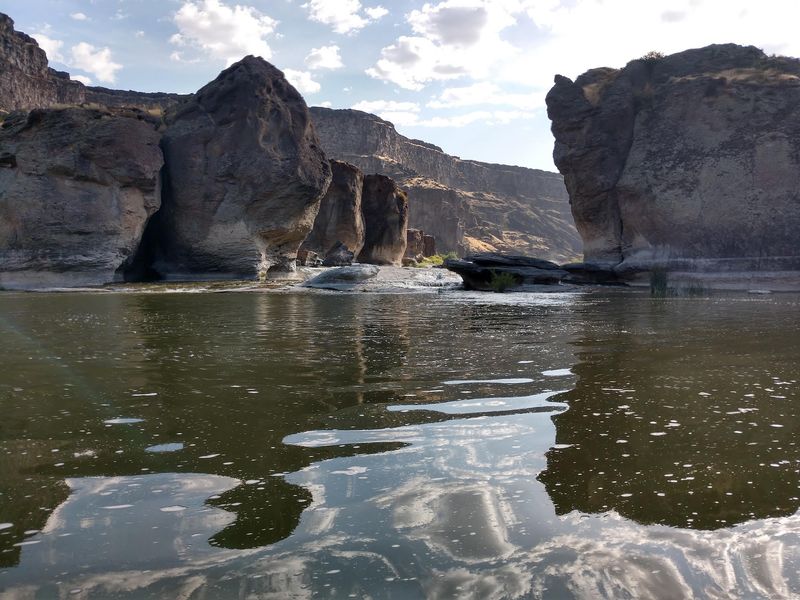
Two massive rock formations rising from the Snake River looked almost unreal, like they had been left behind by a completely different version of Idaho. The effort to get there suddenly made perfect sense.
That two-mile journey was not just a way to reach the destination.
It was the reason the destination felt so rewarding. I have taken plenty of trips where the best part was arriving.
This was different. The adventure started the moment the shoreline disappeared.
Launch Beneath The Canyon Walls And Start Paddling Upstream
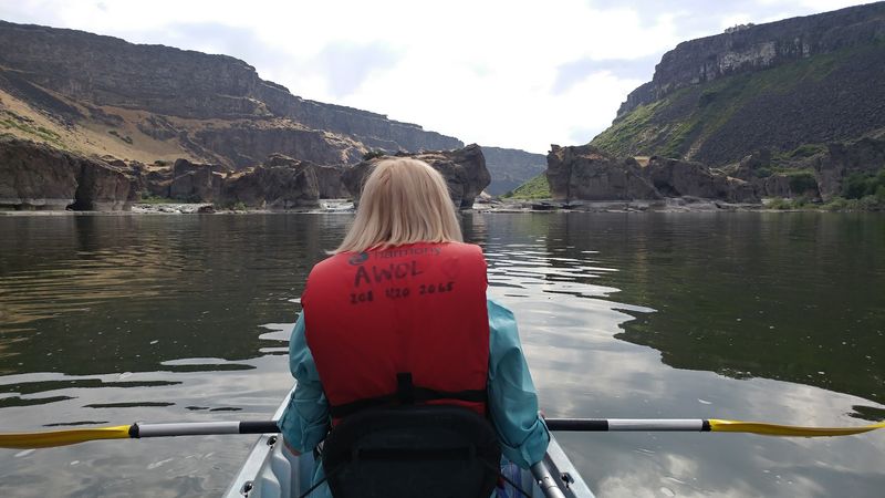
Your first few strokes immediately put the scale of the Snake River Canyon into perspective. Centennial Waterfront Park sits below the canyon rim west of the Perrine Bridge and provides direct river access for paddlers heading east toward Pillar Falls.
AWOL Adventure Sports operates from the park as well, offering kayak and paddleboard rentals for visitors who do not bring their own equipment.
From the launch, the route travels upriver for roughly two miles before reaching the rock formations at Pillar Falls.
That distance sounds modest on paper, but paddling upstream means wind, current, temperature, and individual fitness can noticeably change how the trip feels.
Rather than relying on a fixed promise that mornings or evenings will always be calm, check the day’s actual forecast and river conditions before leaving shore.
Twin Falls County currently lists summer park hours beginning at 7 a.m. and requires watercraft to be off the water before closing.
State inspection and decontamination requirements also apply to kayaks and paddleboards using this regulated stretch, so build that process into your plans before launch.
You Can Pass Directly Beneath The Perrine Bridge On The Way
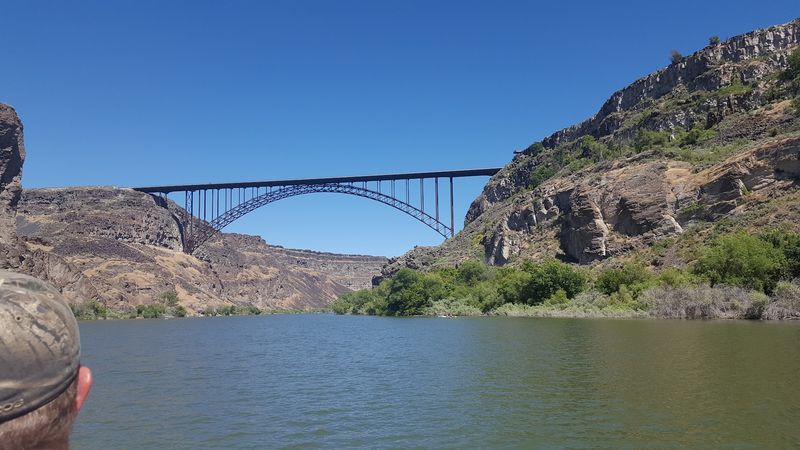
Look up as you approach the first major landmark because the perspective changes completely from river level. The I.B.
Perrine Bridge stretches across the Snake River Canyon above Twin Falls, and paddlers heading from Centennial Waterfront Park toward Pillar Falls travel directly beneath it.
Idaho Tourism describes the distinctive truss arch as rising almost 500 feet above the water, making its size much easier to appreciate from a kayak than from a quick roadside stop.
The bridge arrives relatively early in the journey, with regional paddling guidance placing it around a mile from the Centennial launch. After passing beneath it, another stretch of river leads toward Pillar Falls.
The contrast between the engineered span overhead and the canyon walls on either side already gives the route plenty of visual interest. Pause only where conditions allow, remain aware of other river users, and continue east when you are ready.
Once the bridge begins shrinking behind you, the two rocky pillars ahead become the next major landmark worth watching for.
Watch The Canyon Narrow As The City Disappears Behind You
Soon the buildings above the rim matter much less than the geology surrounding the river. Southern Idaho’s landscape reflects a long history of volcanic activity, and USGS research documents both basalt and rhyolite across the Snake River Plain.
The Snake River also carried the enormous Bonneville Flood through this region thousands of years ago, contributing to the dramatic landscape visible across southern Idaho today.
That history is more complicated than saying one flood simply carved every cliff into its present shape, so the scenery is best understood as the product of multiple geological processes acting over a very long period.
From a kayak, those processes become easier to notice in exposed rock layers, steep canyon walls, boulders, and the changing shape of the river corridor.
The farther you travel from Centennial Waterfront Park, the less the outing feels centered on the city above.
Keep your focus on navigation rather than trying to study every cliff while moving, but make time to look around when conditions allow. Pillar Falls may be the stated destination, yet much of the appeal comes from the canyon encountered before you ever reach it.
Pull Up Beside The Massive Rhyolite Pillars Rising From The River
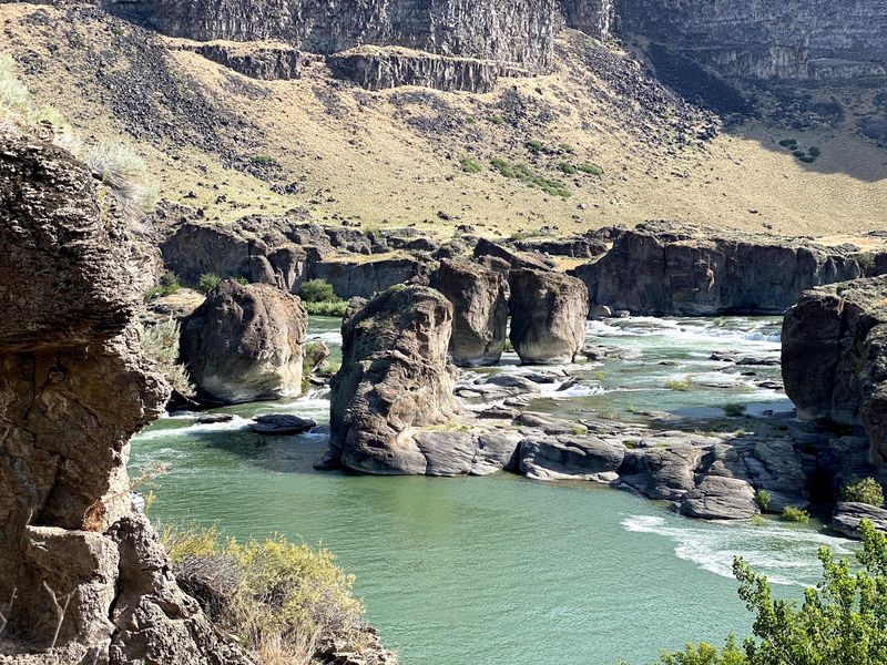
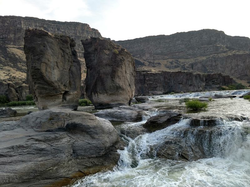
Then the formations that gave Pillar Falls its name finally come into view. Idaho Tourism describes two rhyolite columns roughly 100 feet tall rising at the site, creating an unmistakable landmark about two miles upriver from Centennial Waterfront Park.
Rhyolite is volcanic rock, fitting naturally into the broader volcanic history of the Snake River Plain. Around the pillars, rock formations interrupt the river and create a much more complicated landscape than the broad water encountered earlier in the paddle.
Regional recreation guidance notes that Pillar Falls is effectively the point where paddlers can no longer simply continue straight through the rocky area.
Anyone proceeding farther upriver must deal with the land passage around the falls when current access rules permit it.
If Pillar Falls is your destination, there is no reason to rush beyond the formations. Lower summer water can expose additional rock and pools, giving the area an appearance that changes with river levels.
Secure your craft appropriately before getting out, avoid assuming any particular channel or landing is safe, and choose movements according to the conditions you actually find rather than an old route description online.
Step Out And Explore The Rocky Pools When Water Levels Allow
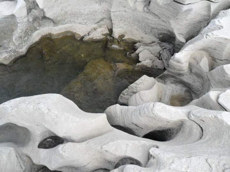
Low water can reveal an entirely different side of Pillar Falls. Visit Southern Idaho notes that summer decreases in river level may expose rock formations and large pools that visitors can explore around the site.
That does not turn the area into a conventional swimming hole or marked hiking trail. Water levels fluctuate, surfaces can be uneven, and regional paddling guidance specifically advises against swimming at Pillar Falls because currents can be unpredictable.
The safest approach is to treat any on-foot exploration as conditional rather than guaranteed. If rocks are exposed and conditions allow, sturdy footwear can make moving across dry or damp surfaces easier, while a dry bag keeps electronics and other belongings protected around the water.
Avoid entering unfamiliar channels simply because they appear calm, and do not assume a route described during one summer will look identical during another. Water releases and seasonal conditions can completely alter what is exposed.
The attraction here is the chance to see the rock formations from river level and, when appropriate, explore a little more closely. There is no prize for pushing farther than conditions comfortably allow.
Bring Enough Energy For The Paddle Back To Centennial Waterfront Park
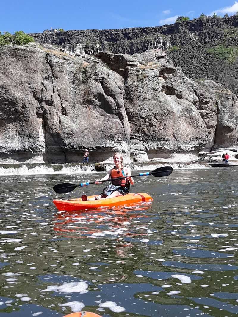
Turning around at Pillar Falls still leaves roughly two miles between you and the launch. That puts the basic out-and-back trip near four miles of paddling, not counting any wandering around the formations or detours along the way.
The return is downriver, but that does not automatically make it effortless. Wind can work against paddlers, temperatures can rise during summer afternoons, and fatigue becomes more noticeable after spending time off the kayak exploring the rocks.
Bring enough drinking water for the entire outing rather than relying on finding anything upriver, and carry a snack if you expect to linger at Pillar Falls.
Restrooms and other park facilities are back at Centennial Waterfront Park rather than scattered along the route.
The smartest turnaround time is one that leaves a comfortable margin before park closing and mandatory watercraft decontamination. Idaho officials encourage paddlers to be off the water early enough to complete required procedures before access areas close.
Once you reach Centennial again, the trip has covered the canyon twice, giving you a second look at the Perrine Bridge and cliffs from the opposite direction.
Check River Conditions Before You Commit To The Trip
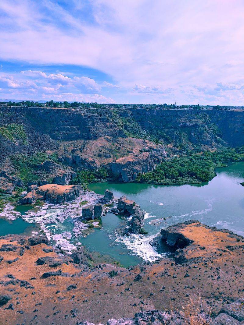
Conditions deserve more attention than any arbitrary number copied from an old paddling guide. Wind, river flow, temperature, water level, equipment, and your own experience all affect whether a trip to Pillar Falls feels comfortable on a particular day.
A better approach is to check current local conditions, talk with an outfitter familiar with the Snake River Canyon, and reconsider the outing whenever weather or water looks beyond your skill level.
A properly fitted personal flotation device should be part of the basic setup for paddling this river.
There is also an additional 2026 requirement that visitors cannot ignore. Idaho’s current invasive-species program requires inspection and decontamination of watercraft using the regulated stretch of the Snake River around Twin Falls, explicitly including kayaks and paddleboards.
Stations operate at designated access points, and the service is free. Those rules can change as conditions and management needs evolve, so checking Idaho’s current Snake River access information immediately before your trip is just as important as checking the weather.
Keep Going Toward Shoshone Falls If You Want A Bigger Adventure
Two more miles upriver leads toward an even larger objective, but this extension requires considerably more preparation than the basic Pillar Falls outing.
Shoshone Falls rises 212 feet, and established paddling routes have historically continued from Pillar Falls by carrying watercraft across the rocky area before relaunching upstream.
Regional guidance places Shoshone Falls about another two miles beyond Pillar Falls, turning the traditional self-powered outing from Centennial Waterfront Park into roughly eight miles of total paddling plus the carry.
Access rules around this stretch have changed repeatedly since invasive quagga mussel larvae were detected in the Snake River, so older instructions should never be treated as current permission to proceed.
Idaho’s present invasive-species program maintains mandatory inspection and decontamination requirements within the regulated river zone, while local outfitters continue to offer guided Shoshone Falls experiences under current operating procedures.
Check state access restrictions and local conditions immediately before attempting anything beyond Pillar Falls.
For many visitors, turning around at the two 100-foot pillars is already a satisfying adventure. Shoshone Falls should only become the next destination when current rules, water conditions, equipment, experience, and available daylight all support continuing safely.