These 12 California Trails Lead To Giant Boulders, Slot Canyons, And Surreal Rock Formations
Rock hikes bring out a very specific kind of curiosity.
A normal trail can be nice. Add giant boulders, narrow canyon walls, strange formations, and stone shapes that look almost designed, and suddenly everyone starts walking slower.
People point more. Phones come out faster. Someone inevitably asks how a rock ended up looking like that, as if the desert or mountains are about to explain themselves.
California’s weirdest trail days often start where the landscape stops behaving politely.
These hikes are built for anyone who likes scenery with texture. The views are not just pretty. They are odd, dramatic, and fun to move through.
A good rock formation changes the rhythm of a hike. It turns the trail into a puzzle, a photo hunt, and a geology lesson nobody had to sit indoors for.
1. Hidden Valley Trail, Joshua Tree National Park
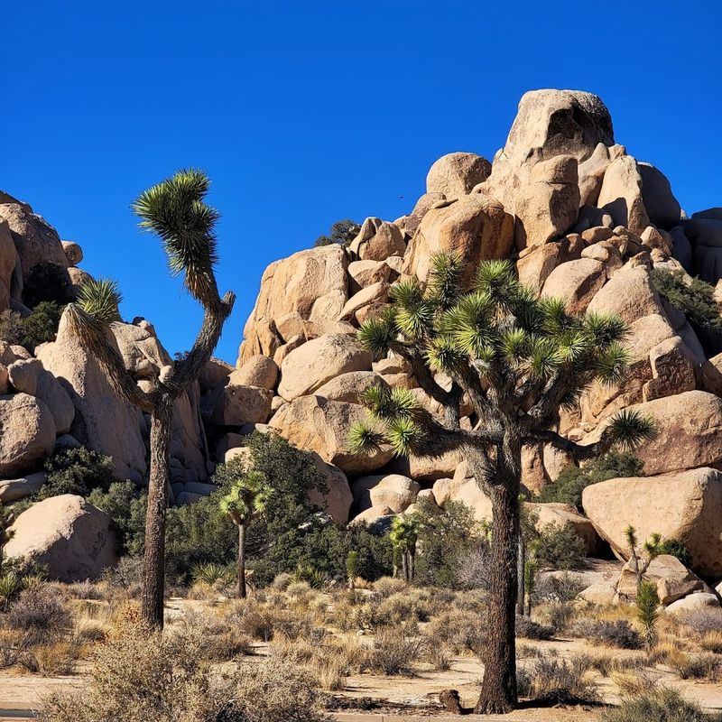
Inside a natural ring of massive granite boulders, Hidden Valley feels like a secret room the desert forgot to lock.
Joshua Tree National Park hosts this easy one-mile loop that introduces visitors to the raw, stacked-rock scenery the park is famous for.
The entry alone, a narrow gap between towering boulders, sets the mood immediately.
Sandy and rocky sections alternate underfoot as the path winds through the enclosed valley.
Interpretive signs along the way explain local plants, desert animals, and the area’s colorful history as a rumored hideout for cattle rustlers in earlier times.
Rock scramblers will find plenty of walls and ledges to explore without straying far from the main route.
The loop typically takes between 30 and 45 minutes to complete at a relaxed pace, though boulder-curious hikers often linger much longer.
A shaded picnic area nestled among the rocks offers a welcome rest spot on warm afternoons.
Arriving early on weekends is strongly recommended since the parking area fills quickly, especially during the cooler spring and fall months when crowds peak noticeably.
2. Hall of Horrors, Joshua Tree National Park
The name alone is enough to spark curiosity, and the landscape behind it absolutely delivers on that promise.
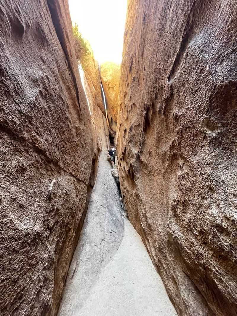
Hall of Horrors sits within Joshua Tree National Park as a rugged cluster of boulder piles connected by dirt paths and narrow rock passages that reward explorers willing to push past the obvious routes.
Climbers have long favored this area for its varied wall angles and satisfying technical routes.
Unlike the more polished trails nearby, this spot has a raw, unscripted quality that makes each visit feel slightly different depending on which direction a hiker chooses to wander.
The passages between boulders can be tight, requiring some careful maneuvering and a willingness to squeeze through gaps that feel surprisingly snug.
That sense of physical problem-solving is a big part of the appeal here.
Casual visitors can enjoy the scenery from the base of the formations without committing to any serious climbing.
The area suits those who prefer an unstructured, exploratory style of hiking rather than a clear marked trail with a defined endpoint.
Checking current park conditions before heading out is always a smart step, as some areas may have seasonal access considerations worth knowing in advance.
3. The Slot, Anza-Borrego Desert State Park
Few places in Southern California pack this much visual drama into such a short distance.
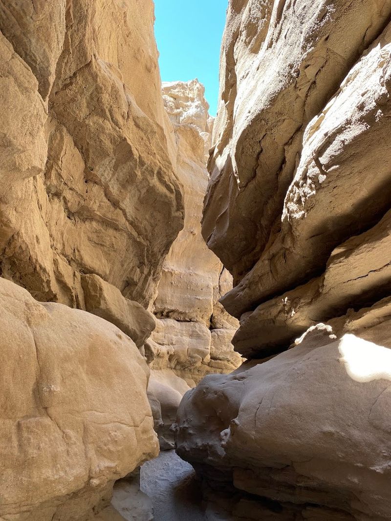
The Slot is a narrow desert slot canyon near Borrego Springs inside Anza-Borrego Desert State Park, and its canyon walls of pink and tan siltstone can rise up to 40 feet while narrowing to just enough space for one person to pass through at a time.
That physical closeness with the rock walls creates a surprisingly immersive feeling.
Hikers can choose between a roughly one-mile out-and-back route or a two-mile loop that adds some elevation gain and deep sand navigation.
The full loop offers a broader sense of the surrounding desert landscape, while the shorter version focuses almost entirely on the canyon passage itself.
Either option delivers the signature squeeze-through moments that make this trail memorable.
The dirt access road leading to the trailhead is generally passable for standard vehicles, though high-clearance cars handle it more comfortably, especially after rain.
Flash flooding is a genuine concern in slot canyons like this one, so checking the weather forecast carefully before visiting is not optional.
Morning visits tend to offer the best light filtering down between the narrow walls, creating striking shadows across the layered stone.
4. Ladder Canyon and Big Painted Canyon Loop, Mecca Hills
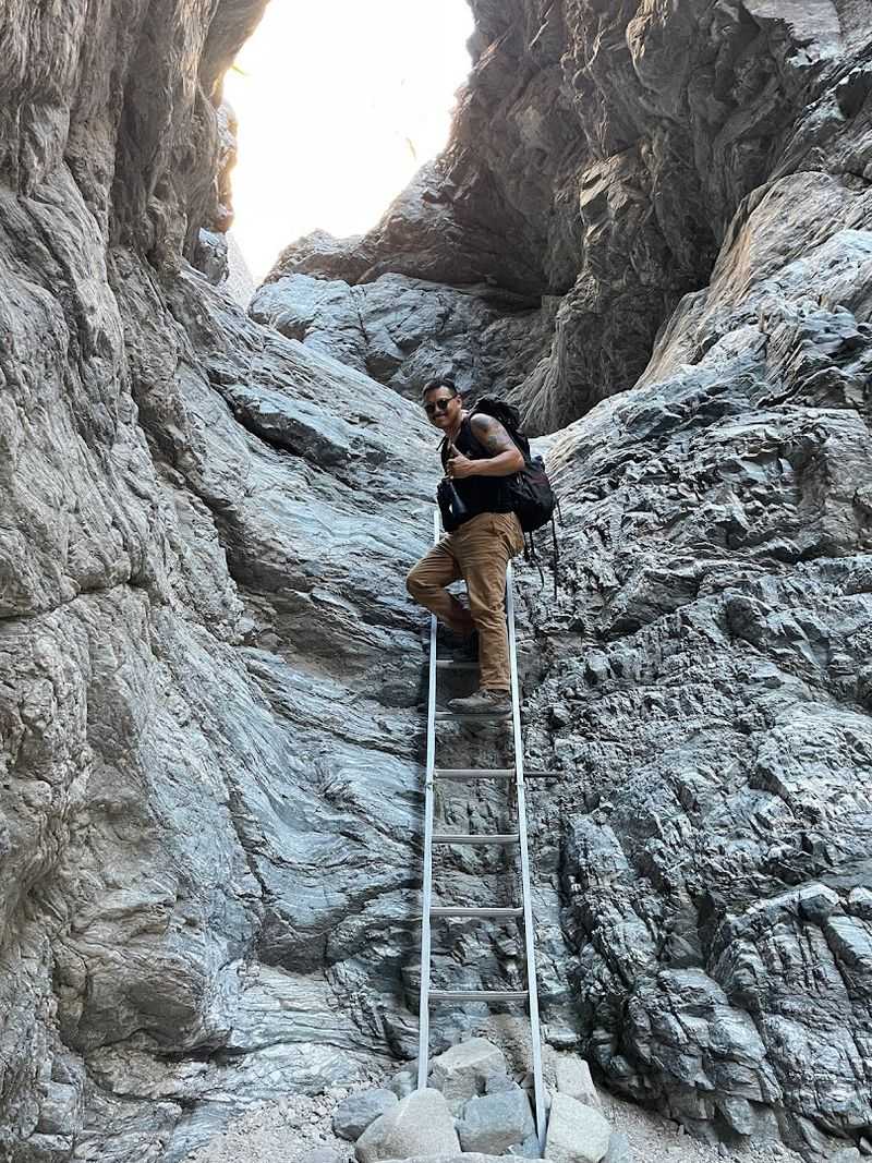
There is something genuinely playful about a hiking trail that requires actual ladders to complete, and Ladder Canyon delivers exactly that kind of hands-on adventure.
Located in the Mecca Hills Wilderness near Mecca, California, this trail winds through tight slot canyons where wooden ladders have been installed to help hikers climb between sections that would otherwise be impassable.
The jagged canyon walls display a remarkable range of desert colors, from deep rust to pale cream.
Combining Ladder Canyon with the Big Painted Canyon Loop creates a longer, more varied experience that moves through different canyon characters within the same area.
Some sections open up into wider passages with layered, painted-looking walls, while others squeeze back down to narrow corridors where the sky above appears as just a thin ribbon of blue.
The contrast between open and confined spaces keeps the hike feeling dynamic throughout.
Footing can be uneven and occasionally loose, so sturdy shoes with good ankle support make a noticeable difference on this route.
The Mecca Hills area sits within a striking geological zone shaped by fault activity, giving the rock layers an unusually dramatic tilted appearance.
Visiting during cooler months is advisable since the desert terrain offers very little shade along most of the route.
5. Mosaic Canyon Trail, Death Valley National Park
Water carved this canyon over an enormous stretch of time, and the results are genuinely stunning to walk through.
Mosaic Canyon Trail near Stovepipe Wells in Death Valley National Park leads hikers through polished narrows where the walls feel almost silky to the touch, shaped by centuries of debris-laden floodwaters grinding the stone smooth.
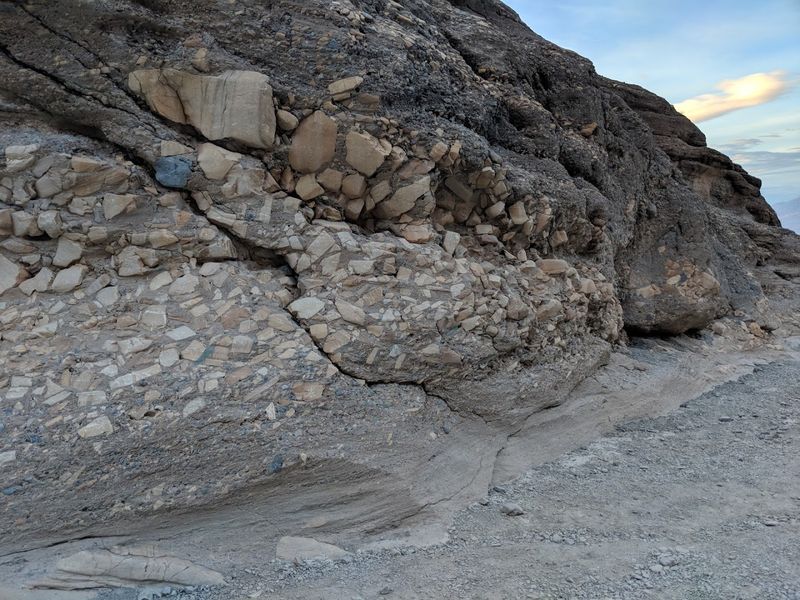
The contrast between that polished surface and the rough mosaic breccia sections makes the geology feel actively interesting rather than just scenic.
Mosaic breccia is a naturally cemented mix of rock fragments, and seeing it up close along the canyon walls adds a satisfying layer of geological curiosity to the hike.
The out-and-back route runs approximately 3.6 to 4 miles round trip with around 750 to 1,200 feet of elevation gain, and the canyon scrambling over dryfalls adds physical engagement beyond simple walking.
Most hikers complete the route in two to three hours at a moderate pace.
The trailhead sits at the end of an unpaved access road west of Stovepipe Wells Village, generally manageable for sedans though large RVs are discouraged on that stretch.
Hiking after 10 AM during summer months carries serious heat risk in Death Valley, so early morning starts are strongly recommended.
The park charges an entrance fee, and rangers suggest carrying far more water than seems necessary.
6. Golden Canyon, Gower Gulch, and Badlands Loop, Death Valley National Park
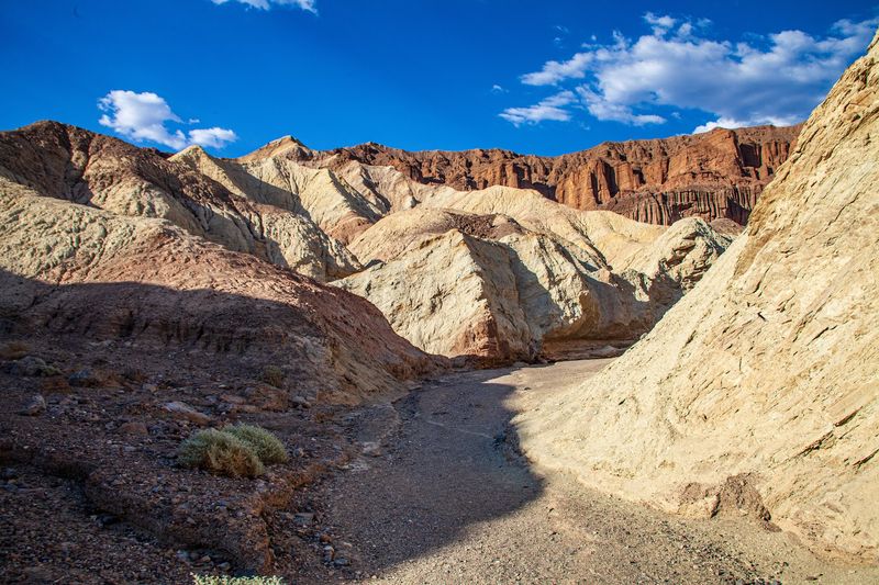
Walking into Golden Canyon feels like stepping inside a geological painting, with walls of amber, gold, and ochre rising steeply on both sides of the trail.
Death Valley National Park’s Golden Canyon to Red Cathedral route covers approximately three miles out and back, gaining around 500 feet in elevation and typically taking one and a half to two hours.
The deep color saturation of the rock is particularly striking in the hour before sunset.
A spur trail branches off toward Red Cathedral, a towering formation streaked with fire-red hues caused by iron oxide minerals in the rock.
That spur can include tight rock-squeeze sections and minor scrambling that adds a satisfying physical challenge to what is otherwise a fairly accessible canyon walk.
Hikers who continue through Gower Gulch encounter a broader desert wash experience with its own distinct character.
Combining all three sections into a full loop creates a route ranging from four to six miles with varied terrain including narrow badlands ridges, open washes, and canyon corridors.
The Golden Canyon trailhead sits two miles south of CA-190 on Badwater Road with a paved parking lot.
Carrying substantial water is essential here, and avoiding the trail during or after heavy rain protects against flash flood risk in these low-lying canyon channels.
7. High Peaks Trail, Pinnacles National Park
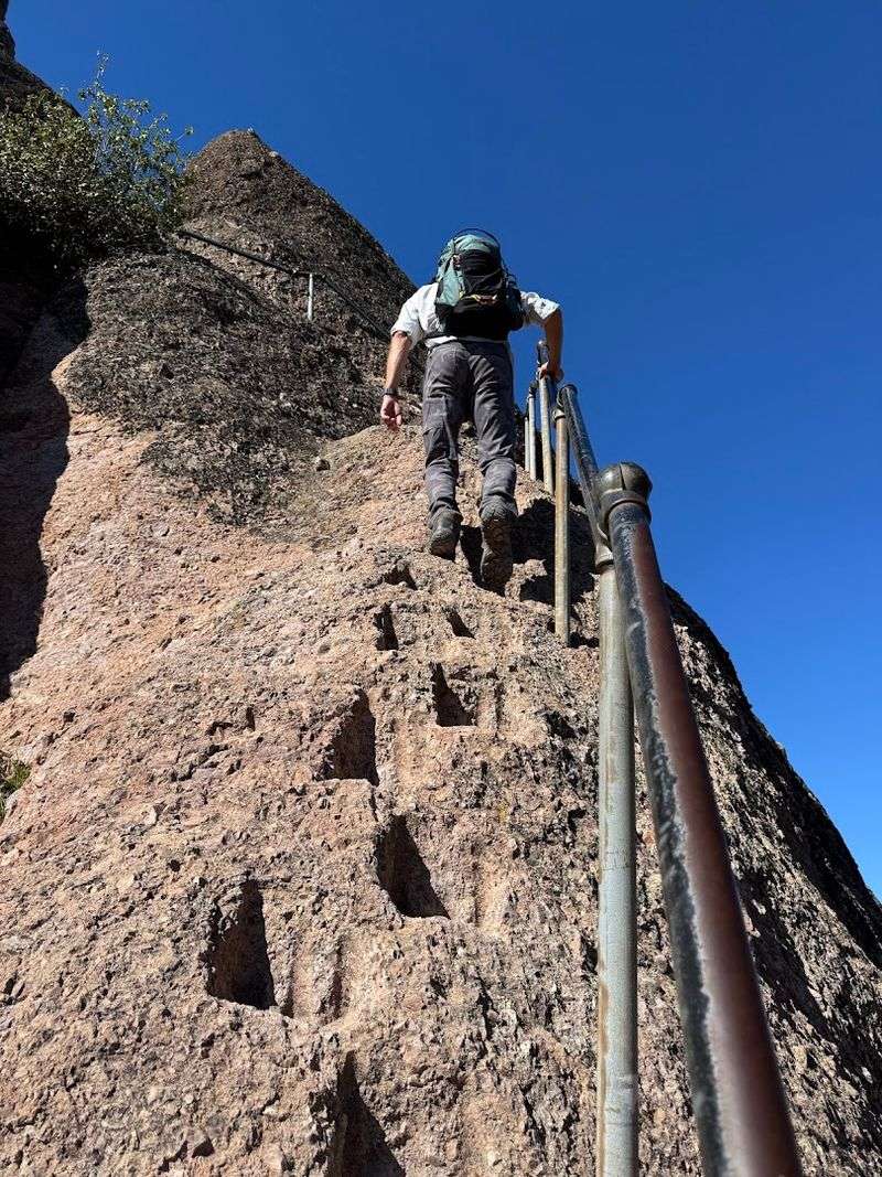
Standing on the High Peaks Trail in Pinnacles National Park, surrounded by jagged volcanic spires that jut upward like broken teeth, it becomes clear why this landscape is considered one of California’s most unusual.
The trail cuts directly through formations left behind by an ancient volcano, with stone stairs chiseled into the rock face and metal railings anchoring hikers along the steepest exposed sections.
The views from the ridge stretch across wide valleys in every direction.
Named formations like the Citadel and Machete Ridge appear along the route, giving the hike a sense of landmark progression that helps measure the distance covered.
The trail runs roughly 4.5 to 9.3 miles as a full loop depending on the chosen route, with over 1,300 feet of elevation gain and a typical completion time of three to six hours. Physical fitness matters here since the terrain is genuinely strenuous in places.
Fall, winter, and spring offer the most comfortable hiking conditions, as summer heat on exposed rock can become intense fairly quickly.
Wet weather makes the stone staircases slippery and significantly increases the difficulty of the steeper sections.
Access is available from both the east and west sides of the park, with the east side offering the option to pass through Bear Gulch Caves on the approach to the high peaks area.
8. Balconies Cave Trail, Pinnacles National Park
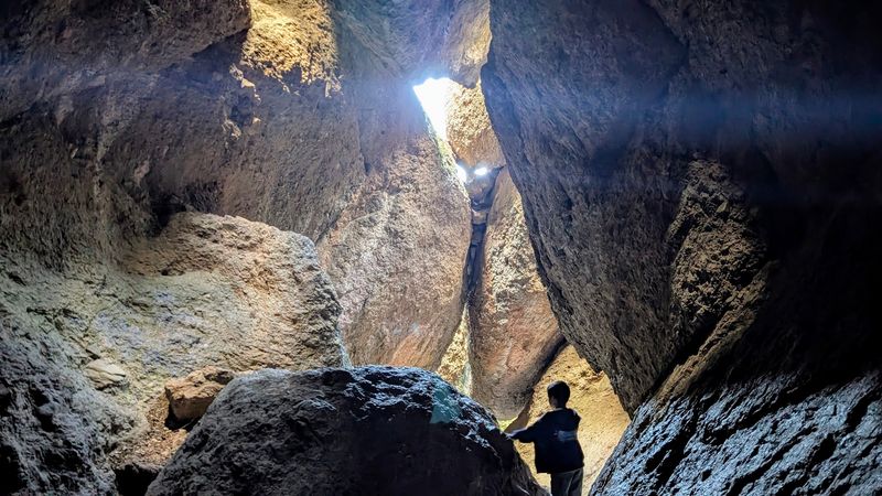
Not every cave involves underground tunnels carved by water, and Balconies Cave proves that point in a thoroughly entertaining way.
Pinnacles National Park’s Balconies Cave Trail leads through talus caves formed when enormous boulders tumbled into a gorge and created a rocky ceiling overhead, leaving a dark, winding passage beneath.
A headlamp or flashlight is not optional here since sections of the cave are genuinely dark and require careful footing.
The trail works as a two-mile out-and-back hike or extends to a 2.4 to 2.6-mile lollipop loop when paired with the Balconies Cliffs Trail above.
Hikers climb over, around, and through boulders during the cave section, which gives the experience a puzzle-like quality that feels quite different from standard canyon hiking.
Water often runs through the cave floor, so waterproof footwear or the expectation of wet shoes is worth planning for.
Seasonal closures do occur at the cave due to bat activity or high water levels following storms, making it essential to check the park’s cave status page before making the trip.
Access typically begins from the Chaparral Trailhead on the west side of the park.
The combination of darkness, boulder scrambling, and narrow passages makes this trail a standout experience that tends to be memorable long after the visit ends.
9. Mobius Arch Loop Trail, Alabama Hills near Lone Pine
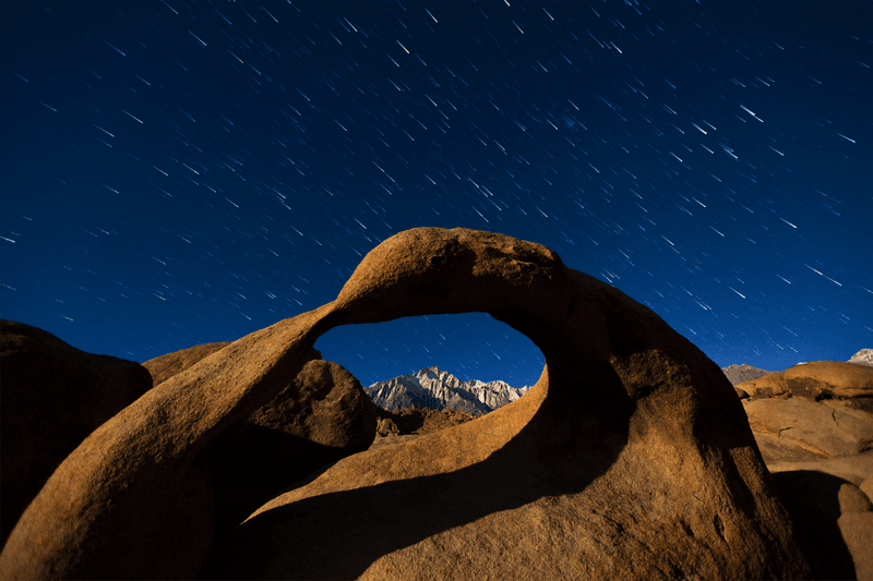
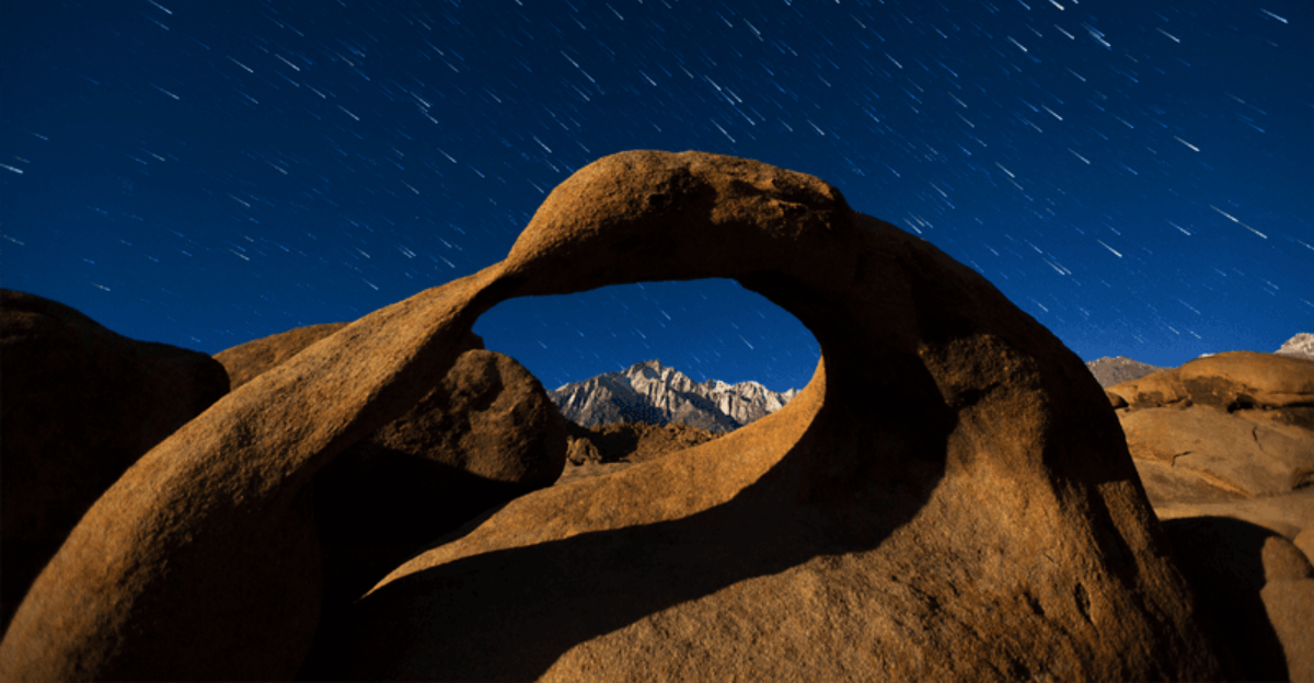
Few short hikes in California offer as much photographic payoff as this half-mile loop through the Alabama Hills near Lone Pine.
The Mobius Arch is the centerpiece, a large boulder sculpted naturally into an arch shape that frames either Mount Whitney or Lone Pine Peak depending on the angle from which a visitor approaches it.
That framing effect, rock arch in the foreground and snow-capped Sierra Nevada peaks in the background, is genuinely hard to forget.
The trail winds through rounded granite boulders and past smaller arches and spires, giving the route a sense of discovery even at its brief length.
Most hikers complete the loop in 30 to 60 minutes, making it an accessible option for families, casual visitors, and serious photographers alike.
The mostly flat terrain keeps physical demands low while still delivering a landscape that feels far more remote than the easy drive suggests.
Photographers tend to arrive around sunrise and sunset when warm light transforms the arch and surrounding boulders into something almost theatrical.
The trailhead is accessible from Whitney Portal Road by turning onto Movie Road, a fitting name given the Alabama Hills’ long history as a filming location for Westerns and science fiction productions.
Weekday mornings offer the quietest experience at what can become a surprisingly busy spot on weekends.
10. Hagen Canyon Nature Trail, Red Rock Canyon State Park
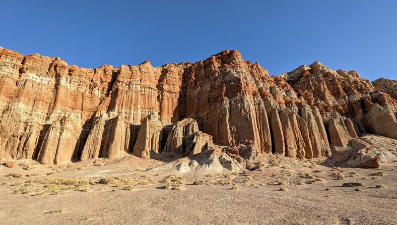
The color contrast at Red Rock Canyon State Park near Cantil is the kind that makes people pull over and stare before they even reach the trailhead.
Hagen Canyon Nature Trail moves through a landscape of striking red cliffs, pale buttes, and layered desert formations that shift in tone and intensity as the light changes throughout the day.
The geological variety packed into this relatively compact area is genuinely impressive.
Volcanic deposits, ancient lake sediments, and erosion-carved shapes all appear along the trail, creating a visual record of dramatically different environmental eras.
The formations here include some unusually tall and narrow spires that cast long shadows across the sandy ground during morning hours, adding a quiet drama to an already striking environment.
Wildlife including birds of prey, desert reptiles, and small mammals may be spotted along the route.
Red Rock Canyon State Park sits along Highway 14 between Mojave and Ridgecrest, making it a natural stopping point on longer drives through the high desert region.
The park is generally open to visitors and offers camping facilities for those who want to experience the canyon light at different times of day.
Visiting in spring may bring wildflower color to the desert floor, adding an unexpected softness to the otherwise rugged rock scenery throughout the canyon area.
11. Vasquez Rocks Geology Trail / PCT Loop, Agua Dulce
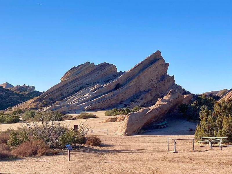
Tilted at steep, dramatic angles that seem to defy gravity, the sandstone slabs at Vasquez Rocks have been catching eyes for a very long time.
Tthe Vasquez Rocks Geology Trail and PCT Loop offer easy access to one of Southern California’s most visually distinctive geological features, where ancient fault activity pushed massive rock layers upward at striking diagonal angles.
The formations are recognizable to many visitors who have seen them used as a filming backdrop in countless productions over the decades.
The geology trail itself provides interpretive information about how the San Andreas Fault system shaped the landscape over millions of years, giving the walk an educational quality that complements the visual spectacle.
The Pacific Crest Trail passes directly through the area, connecting the rocks to a broader hiking network for those who want to extend their time on the trail.
Shorter loop options keep the route accessible for hikers of varying fitness levels.
The park is managed by Los Angeles County and is open to the public, with parking available near the main trailhead area.
Mornings tend to offer the best light on the rock faces, and weekdays are noticeably quieter than weekends when the dramatic scenery draws larger crowds.
Bringing sun protection is practical since shade is limited along most of the exposed rock sections throughout the loop.
12. Devil’s Punchbowl Loop or Devil’s Chair Trail, Pearblossom
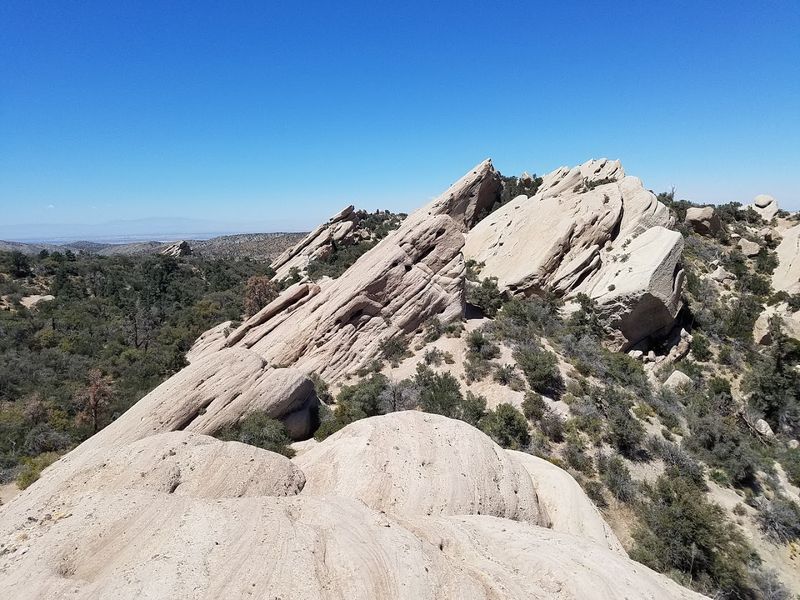
Fault lines rarely announce themselves this dramatically, but at Devil’s Punchbowl Natural Area near Pearblossom, the evidence of tectonic forces is impossible to miss.
Massive rock walls have been pushed upward and twisted by the San Andreas and Punchbowl fault systems, creating a canyon landscape of jagged, uplifted slabs that lean at impossible-looking angles.
The overall effect is deeply geological in the best possible way.
The Devil’s Chair Trail leads out to a promontory overlooking the canyon, offering a bird’s-eye perspective on the uplifted rock formations below.
From that vantage point, the full scale of the geological disruption becomes visible in a way that ground-level views cannot quite capture.
The loop option allows hikers to experience the canyon from multiple elevations and angles throughout a single outing.
The surrounding high desert environment sits at the transition zone between the Mojave Desert and the San Gabriel Mountains, which gives the area a layered ecological character beyond just the dramatic rock scenery.
Chaparral, desert scrub, and conifer-adjacent vegetation appear in different sections depending on elevation and aspect.
The natural area is managed by Los Angeles County and generally open to the public, with a small nature center near the entrance providing useful context about the geology and wildlife that call this unusual fault-carved landscape home.