These 8 Beautiful Idaho Trails Start Breezy And End With Unforgettable Views
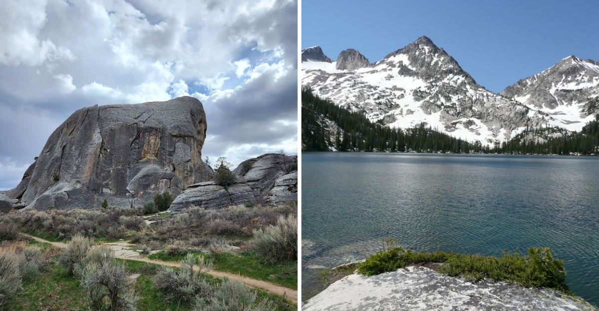
Trails that start easy and close with a view are the best kind. Idaho has trails that follow exactly that arc and deliver every single time.
The early miles ease you into a rhythm before the landscape starts performing. What waits at the end of each of these earns every step before it.
I have started more than one thinking it would just be a quick walk. It never is, and I mean that entirely as a compliment to the trail.
Right around the final bend on most of these, something remarkable opens up ahead. Breezy and moderate starts make the unforgettable endings feel like gifts you did not plan for.
Lace up, bring layers, and let Idaho take you all the way through.
1. Window Arch Trail
Trust me, not every trail that looks simple on a map ends with something this dramatic.
The Window Arch Trail sits inside City of Rocks National Reserve, near Almo in southern Idaho. It is a short but rewarding hike that surprises even experienced trail walkers.
The path begins on fairly flat terrain with loose gravel underfoot. Sagebrush lines the sides and the air carries that dry, clean scent of the high desert. You move at a comfortable pace without much effort at all.
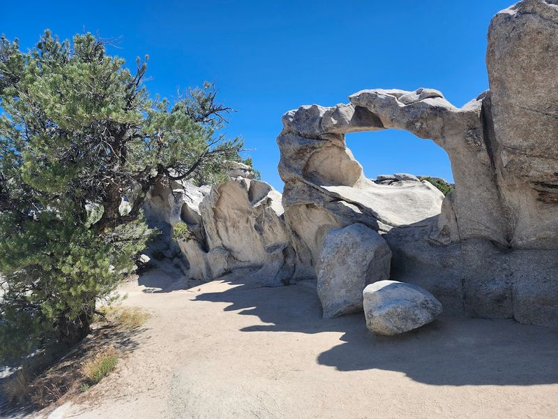
Then the trail tilts upward slightly, guiding you toward a massive granite formation. The arch itself is carved naturally into the rock face.
Standing beneath it and looking through the opening feels like peering through a window into another world.
The views beyond the arch stretch across rolling hills and open sky. On clear days, distant mountain ranges appear on the horizon. The contrast between the rough stone frame and the soft landscape behind it is genuinely stunning.
Early morning light hits the arch at a beautiful angle. Photographers especially love arriving just after sunrise. The golden tones on the granite make every shot look professionally composed.
Wildlife sightings along this trail are not unusual. Keep your eyes open for mule deer, hawks, and small lizards darting across the rocks. Wearing sturdy shoes with good grip helps on the rockier sections near the arch.
Spring and fall are the most comfortable seasons for this hike. Summer heat can make the exposed sections tiring. The trail is family-friendly and takes roughly one hour round trip.
2. Geological Interpretive Trail
Believe me, walking across a landscape that looks like the surface of another planet is something you will not forget quickly.
The Geological Interpretive Trail winds through Craters of the Moon National Monument, located near Arco in central Idaho. It is short, flat, and packed with fascinating natural history.
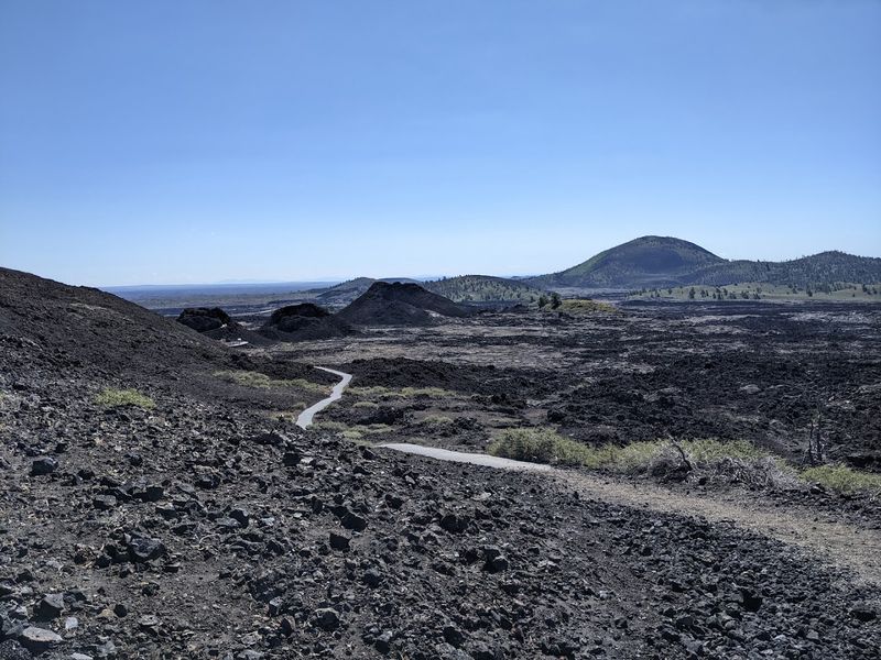
The trail begins at the main loop road inside the monument. Right away, the black lava rock stretches in every direction. The contrast between the dark ground and the bright sky is striking from the very first step.
Informational signs line the path and explain the volcanic features you pass. You learn about lava tubes, cinder cones, and spatter cones as you walk. It turns a simple hike into something closer to an outdoor classroom.
The landscape here formed from eruptions that occurred as recently as 2,000 years ago. That geological youth makes the terrain look almost untouched. Patches of hardy plants push up through cracks in the lava, showing real resilience.
Views from the higher sections of the trail include sweeping panoramas of the lava fields. The distant Pioneer Mountains appear on the horizon to the north. The scale of the volcanic landscape becomes clear from these elevated points.
Morning hikes here are especially peaceful since crowds tend to arrive later in the day. The air is crisp and the light is soft and golden. Sunscreen and water are essential since shade is nearly nonexistent along the route.
The trail is accessible for most ages and abilities. It takes about 45 minutes to complete at a relaxed pace.
3. Creekside Towers Trail
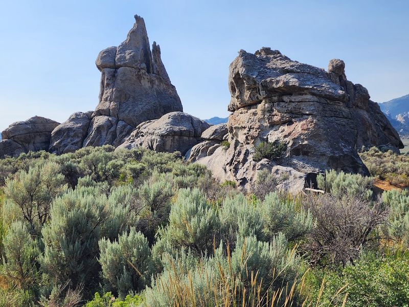
I never would have guessed that a trail following a small creek could lead to some of the most towering rock formations in southern Idaho.
Creekside Towers Trail runs through City of Rocks National Reserve near Almo, in Cassia County. The combination of water, greenery, and granite makes it one of the most visually varied hikes in the reserve.
The trail starts along a gentle creek lined with willows and cottonwoods. The sound of moving water sets a calm and easy rhythm for the walk. Shade from the trees keeps the lower section cool even on warm days.
As the path continues, the creek vegetation gives way to open rocky terrain. The granite towers begin rising on both sides of the trail. Their height and texture create a dramatic corridor that frames the sky above.
The towers themselves are impressive up close. Looking straight up at them from the trail gives a real sense of how small you are in this landscape.
Birdsong is constant along the lower creek section. Warblers, swallows, and the occasional raptor circle above the towers. The wildlife activity adds life and sound to what might otherwise feel like a silent, stone world.
Late spring brings the best combination of green creek vegetation and clear skies. Summer mornings are also excellent before the heat builds.
Lightweight layers work well since temperatures can shift between the shaded creek and the exposed upper sections. The trail is moderate in difficulty and takes about 90 minutes.
4. Castle Rocks, Backyard Boulders Trail
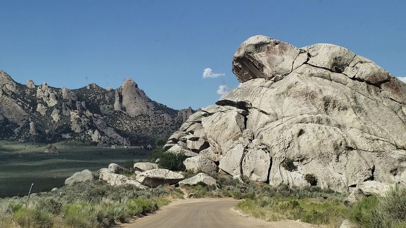
Can you believe that some of Idaho’s most dramatic rock formations are hiding in a state park that most people have never heard of?
The Backyard Boulders Trail runs through Castle Rocks State Park near Almo in southern Idaho. It connects directly with City of Rocks National Reserve and shares the same spectacular granite scenery.
The trail starts across open grassy meadows with a gentle, easy grade. The boulders visible in the distance seem to grow taller with every step you take toward them.
That slow reveal builds a real sense of anticipation. As you get closer, the scale of the granite formations becomes almost hard to process.
Some boulders are the size of small buildings. They cluster together in natural groupings that look almost deliberately arranged.
The trail winds between and around these formations, giving you close-up views from multiple angles. Textures in the rock range from smooth and rounded to rough and fractured. Each surface tells a different part of the same long geological story.
Views from the upper sections of the trail include open ranch land and rolling hills to the south. The Albion Mountain Range frames the horizon to the east. That combination of pastoral and rugged scenery is genuinely hard to find anywhere else.
Rock climbers frequent this area and their colorful gear adds movement to the otherwise still landscape. Watching a climber work a route on a tall face is quietly inspiring.
Even standing at the base of those routes feels like an achievement.
The trail is well-marked and takes about two hours round trip. Early risers get the best light and the quietest experience.
5. City Of Rocks Loop
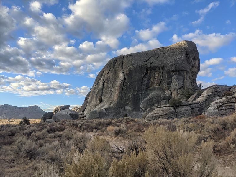
Who would have thought that a loop trail through a place called City of Rocks could genuinely feel like walking through an ancient, silent city?
The City of Rocks Loop winds through City of Rocks National Reserve near Almo, in Cassia County, southern Idaho. It is the most comprehensive trail in the reserve and covers a wide range of terrain.
The trail begins on a well-graded path that moves gently upward from the trailhead. Sagebrush and scattered wildflowers line the route in spring and early summer.
The pace at the start is easy and the scenery builds gradually.
As the loop progresses, the granite formations become increasingly impressive. Towering spires, rounded domes, and fractured walls appear around every bend.
The variety of shapes keeps the experience feeling fresh throughout the entire route.
Historic California Trail wagon ruts are still visible in certain sections of the reserve. Emigrants passed through this same landscape in the 1840s and 1850s. That connection to history adds a layer of meaning to every step.
The highest points on the loop offer sweeping views across the entire reserve. The rock formations spread out below like a natural skyline. On clear days, the Albion Mountains rise sharply to the east.
Wildlife here includes everything from marmots to golden eagles. Spotting a raptor gliding between the spires is a moment that stays with you. Binoculars are worth carrying for the bird-watching opportunities alone.
The full loop takes three to four hours depending on your pace. Bring enough water since shade is limited in the upper sections.
6. Stripe Rock Loop
I must admit, finding a rock with natural stripes bold enough to stop you mid-step is not something I expected on a casual afternoon hike.
The Stripe Rock Loop trail runs through City of Rocks National Reserve, located near Almo in southern Idaho. It is a circular route that rewards curiosity at every turn.
The loop begins on a well-worn dirt path with minimal elevation change at the start. Sagebrush and bunchgrass fill the open spaces between rock formations.
The early section moves at a relaxed and comfortable pace.
Stripe Rock itself is the undeniable highlight of the route. The formation displays bold horizontal bands of color caused by contrasting mineral deposits in the granite. Up close, the stripes are vivid and almost hard to believe are entirely natural.
The loop continues past several other notable rock clusters after Stripe Rock. Each formation has its own personality and shape. Some look like stacked blocks while others taper into sharp, narrow spires.
Views along the upper portion of the loop open toward the broader reserve landscape. Rolling terrain, scattered juniper trees, and distant ridgelines fill the background.
The quiet here is the kind that makes your thoughts slow down naturally.
Afternoon light brings out the warmest tones in the granite. The stripes on Stripe Rock glow especially well in that golden hour before sunset. Photographers who time their arrival well are rarely disappointed.
The loop takes about 75 minutes at a steady pace. The terrain is mostly moderate with a few short rocky sections.
7. Alice Lake, Toxaway Loop
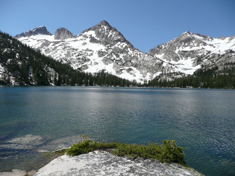
Doesn’t it seem almost unfair that one trail can pass two stunning alpine lakes and cross through some of the most dramatic mountain scenery in all of Idaho?
The Alice Lake and Toxaway Loop travels through the Sawtooth Wilderness near Stanley in central Idaho. It is a multi-day backpacking route that earns every superlative thrown its way.
The trail begins at the Petit Lake trailhead and follows a well-marked path through pine forest. The early miles are shaded and relatively flat, making them ideal for warming up your legs.
The forest floor is soft with pine needles and the air carries a sharp, clean mountain scent.
As the elevation increases, the trees thin out and the views begin to open. Granite peaks appear above the ridgeline ahead. The anticipation of what waits beyond each rise keeps your feet moving forward.
Alice Lake sits at roughly 8,600 feet and is nothing short of spectacular. The water is a deep, clear blue surrounded by jagged peaks. Camping near the shore on the first night is an experience that is hard to put into words.
The Toxaway Lake section of the loop adds another dimension entirely. That lake sits slightly higher and feels more exposed to the sky. The reflections of the surrounding peaks in the still water are extraordinary.
Wildflowers carpet the meadows between the lakes in midsummer. Blues, yellows, and purples spread across the terrain in dense patches. The color against the grey granite and blue water is genuinely breathtaking.
The full loop covers approximately 18-22 miles, depending on the route. Permits are required for overnight stays in the wilderness.
8. Bath Rock Trail
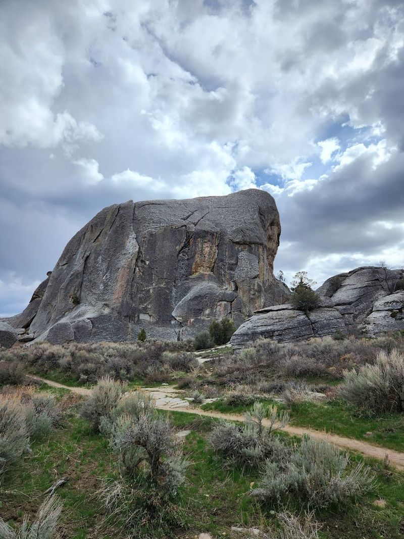
Would you ever think a trail named after a rock could leave you completely speechless by the end?
Bath Rock Trail runs through City of Rocks National Reserve near Almo, in Cassia County, southern Idaho. It is one of those hikes that feels almost too easy at first.
The trail begins gently, cutting through open sagebrush flats. The ground is mostly packed dirt with scattered pebbles.
A light breeze usually moves through the area, making the start of the walk pleasant and cool.
As you continue, the granite formations grow taller and more dramatic around you. The rocks here have smooth, rounded surfaces shaped by thousands of years of natural weathering.
Some formations lean at wild angles that make you pause and stare.
Bath Rock itself is a large, distinctive granite dome that rises above the surrounding landscape. Climbing to its base gives you a sweeping view of the reserve below.
The layered ridgelines in the background add real depth to the scenery.
This trail is also a favorite among rock climbers who use the area regularly. Watching them scale the sheer faces adds an exciting energy to the hike. You do not need to climb anything yourself to fully enjoy the experience.
Wildflowers bloom along the lower sections in late spring. Their colors pop against the pale granite and dusty soil. Bringing a light jacket is smart since the elevation can make afternoons cooler than expected.
The trail is moderate in length and suitable for most fitness levels.